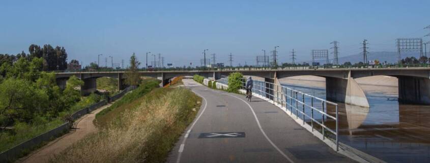
This Is What a Bike Highway Could Look Like
The Bike Highways Bill, AB 954, passed the Assembly by a wide margin, showing strong support for protected, connected bikeway networks. CalBike is sponsoring this bill, authored by Assemblymember Steve Bennett, which will create a pilot project pathway to create bike highway networks in two regions.
The networks could be planned using existing segments of fully separated bike paths and on-street protected bikeways, as well as new facilities. Creating a regional network that allows riders to seamlessly get where they need to go without facing missing links or dangerous intersections is the magic of the bike highways plan. This project could significantly increase bicycle mode share and become a model that can be replicated throughout California.
Although we don’t have complete bike highway networks yet, there are several existing bikeways used for long-distance bike commuting. We spoke to some of the people using one of these bikeways in Southern California.
“AB 954 is our chance to link the enormous stack of bicycle benefits with well-connected, longer-range networks. In Burbank, for instance, major bike paths including the Chandler, the San Fernando, and the Channel Bikeways, do not connect to each other or to the Los Angeles River Bike Path. Without safe, direct connections, these human-powered corridors remain isolated and ineffective. Bike highways are the way to weld segments together into something truly useful. By linking these networks, we unlock a complete system where biking becomes not just possible, but a life-affirming celebration for all.” — Kreigh Hample, Project Coordinator for Walk Bike Burbank and the Burbank Advisory Council on Disabilities
Southern California Trails
The San Gabriel River Trail is a 35.4-mile multi-use path. The LA County website lists mountain biking as one of the uses and seems to view the trail from Seal Beach to Azusa as recreational. We reached out to users via Reddit and found at least one bike rider who uses it for commuting as well as recreational rides.
“The SGRT is one of the few places where cyclists can truly bike without ever encountering the crazy drivers of LA,” Justin Williams told CalBike. “I use the path to commute to work and on the weekends for fun. It is one of the only ways to cross the 405 without on/off ramps… PCH gets sketchy, and I wouldn’t recommend it to my friends.”
The trail passes through numerous cities, including Norwalk and El Monte, and could provide the basis for a bike highway network if connected with local bike routes.
An anonymous commenter rides the San Gabriel River Trail but prefers the Santa Ana River Trail farther south for recreational rides because of poor pavement in some sections of the SGRT. The San Gabriel River Trail is shared with horseback riders, and some sections are gravel rather than asphalt.


The Santa Ana River Trail is an ambitious project to build 110 miles of trail from the San Bernardino National Forest to the Pacific Ocean in Huntington Beach. This trail, which started construction in 2005 and is 60% complete, will ultimately pass through San Bernardino and Santa Ana. It will end at the Pacific Coast Highway, a few miles south of Beach Boulevard, a state route that CalBike evaluated as part of our Incomplete Streets report.
While these two trails are largely intended for recreational bike riding, they could provide the spine for connected, protected bike highway networks, allowing people to travel by bike between and within Southern California communities. There are numerous trails like this throughout California. With your help, we’ll pass the Bike Highways Bill and experience the positive impact of truly regional bikeway transportation networks.


